Bayou Manchac A to A — Recon

We had heard various reports about the state of Bayou Manchac with respect to litter, so we decided it was time for a nice recon run up and down the entire navigable length of Bayou Manchac. Basically, a “Bayou Manchac A to Z”, except the two ends are the Amite River and Alligator Bayou, so make that “Bayou Manchac A to A”.
We put in at the small launch off the end of Ducros Road. Someone had apparently been cleaning fish and dumping the remains right on the ramp, making for a nauseating start to the day. The convenience of launching wasn’t *completely* offset by the revoltingly odoriferous circumstances, so we pressed on. At about twenty past nine, we began the run.

The first thing we noticed was the almost uninterrupted parade of scattered litter lining the banks. This was not concentrated litter rafts being strained by trees and obstructions. Rather, it was just general background litter present throughout the waterway.
In some ways, collecting litter from the concentrated litter rafts is “easier” than collecting this background litter. One or two people can work a litter raft and clear it all at once, but this background litter must be picked up one piece at a time. This would be a problem for which an organized litter cleanup would be ideal.

Of course, this background litter is only one part of the litter problem on Bayou Manchac. There are many litter rafts, both large and small, scattered throughout the length of the bayou. They also vary significantly in composition. Some appear to have a very high concentration of litter, while others have a smattering of litter interspersed throughout a much larger amount of woody debris. As the woody debris need not be collected when collecting litter by hand, the litter rafts with less litter and more woody debris will require less litter-carrying capacity for a given area.


The most significant of the litter rafts, as well as the highest concentration of background litter, were found from the vicinity of the mouth of Ward Creek to the Ducros Road boat launch (with a lesser amount present through the mouth of Muddy Creek). Upstream of the mouth of Ward Creek, the litter concentration diminished rapidly to a very low level, and downstream of Muddy Creek, there was only a much lower level of background litter and a few larger objects.
It would appear, then, that most of the litter entering Bayou Manchac is entering from Ward Creek. Although Bayou Fountain does have a litter problem, Project Flowing Fountain showed much less general litter than the Ward Creek recon run and subsequent excursions. As observations of Bayou Manchac appear to be strongly in agreement with direct observations of its tributaries, we can be considerably certain that Ward Creek provides the greatest potential for preventing litter from flowing into Bayou Manchac.
As the flow was up after recent rains, we also took a moment to note the state of a sampling of litter actively flowing down Bayou Manchac just downstream of the mouth of Ward Creek. As we passed by the trail of litter, we took a set of photos to show the quality of litter present. In the five photos, there are four bottles with no remaining label, one bottle with a very faded label, one chunk of well-weathered polystyrene foam, and one foam cup that had seen better days.


As the cup was not very faded, it may have been fairly recent litter. The bottles and foam, however, showed significant signs of having spent quite some time out in the sun. This is significant in light of information gleaned from prior days spent on Ward Creek. Specifically, there was not a large amount of litter in Ward Creek downstream of Highland Road. As the sample of litter was generally quite well seasoned, it would seem very likely that it was coming from farther upstream (such as the vast amounts of litter found between Siegen Lane and Pecue Lane).
There have been discussions about putting a litter trap somewhere on Ward Creek in order to document and mitigate the amount of litter flowing into Bayou Manchac. (The litter trap could be something as simple as a bit of floating boom that would catch the floating litter while allowing the water to continue along unimpeded.) Placing this litter trap in an accessible location just upstream of the Highland Road bridge would seem to be a supportable proposition. The rip-rap at the Highland Road crossing should preclude any interaction with powered watercraft. With a litter trap in place, litter cleanups starting with the lower portion of Ward Creek and continuing down Bayou Manchac should create a direct and immediate improvement to the litter situation.
For the time being, there is significant opportunity for organized litter cleanups launched from Santa Maria, the State Fairgrounds, Manchac Park/LA 73 (Old Jefferson), or Camp Drive. A litter trap on Ward Creek would reduce future recontamination, but there is no justifiable reason to leave the current litter in place in the meantime. Bayou Manchac can be paddled from Alligator Bayou to the Amite River without difficulty, and there’s work to be done.
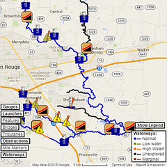
The photos taken during the recon run have been mapped out for your viewing convenience. Check out the map via Google Maps or download the kmz file for Google Earth.
Bayou Manchac A to A — Recon statistics:
- Elapsed time: 7 hours
- Total distance: 21.3 miles (round trip)
- Parishes set foot upon: 4 (Ascension, Iberville, Livingston, East Baton Rouge)