Project ReWard — Expedition Seven

There was quite a current for Ward Creek when we headed out for Expedition Seven of Project ReWard, but we weren’t going to let that stop us from some rework on a couple bridges. Not to mention, current can also be useful.
We got a message earlier in the week asking if we could use a couple guest volunteers who needed to log some service hours, and since we can always use more help, we said certainly. They met us at Manchac Park and grabbed another canoe off the trailer, and upstream we all headed. With the thunderstorms overnight, the current was up on Manchac and Ward, but they managed to struggle through it with only one paddling anomaly caused by the very high current under Highland Road.

Soon enough, we made it to Barringer Foreman, where a bit of a jam has been collecting since we originally cleared it. Since Mike and I are experienced paddlers well accustomed to working from canoes and in currents, we worked the jam from the water. Meanwhile, we put our guest volunteers ashore to handle rope work. Tying off logs for them to pull free made working in the strong current much more pleasant, and in less than three hours, the bridge was once again clear.

With Barringer clear, we continued upstream just a bit more to the Derelict Bridge by Buzbee Drive, which had collected a bit (but not too much). Most of the work was just logs caught on the legs (for once, not dam-like), so we all worked from our boats and made quick work of it. For the most part, it was just a matter of pulling the tangled bits free, with just a bit of sawing.

Of course, that one large log (bright in the aerial) merited special treatment. We took about six feet off the “small” end, but being a full tree trunk, it was still long enough that there was a very good chance of it catching at Barringer just under half a mile downstream. Conveniently, we happened to have quite a nice current. We tied off to the narrow end and towed the trunk all the way to and through the bridge at Barringer. (With the six feet cut off the end, it’s no longer long enough to span a full bay at Highland.)

With the Derelict and Barringer clear, we called it a day and headed back downstream to Manchac Park. Along the way, a light misting finally arrived, giving us the first precipitation of the whole trip, but it wasn’t enough to even consider it a sprinkle. Thanks to the current, we arrived back at the park in no time flat. We sent our guest volunteers on their way with our gratitude for their 7-1/2 hours of service, and we loaded up to head home (at which point the rain finally arrived in earnest).

With the former Ward Creek Lumberyard at Pecue all clear as of Expedition Six and the rework on the Derelict and Barringer now also complete, all the bridges along the paddeworthy length of Ward Creek are now fully open. We’ll monitor them and hit them up for any rework that becomes necessary as things continue to settle out, but the bridge portion of Project ReWard can now shift into maintenance mode. That does not, however, mark the end of Project ReWard itself, as we have one more area that we have left to address: the slide area (just downstream of I-10).

Working the slide area is contingent on the water level being low enough to access the logs, tree trunks, and debris embedded in the bottom. If the water levels cooperate, it might only take a few trips to restore an unobstructed low-water channel, but it’s going to take quite a bit of pulling and cutting. (If anyone with a chainsaw wants to get a bit of work in, that could also help — as we pull the pieces out of the water, we’re going to need to cut them into shorter pieces so they don’t jam the bridges downstream.) Anyway, it should be interesting work, and now it’s all that stands between us and declaring victory for Project ReWard. Give us some dry weather and low water, and we can hardly wait to get started.


Question. Regarding Expedition 7, you say you launched at Manchac Park. Exactly where is that?
I’ve been admiring your work for a while now
And I am truly amazed. It must give you a great sense of satisfaction in a job well done.
But I now would like to know what you think about the new multimillion dollar project to clear and dredge these canals. Will you get to have any input as experts in the field.
Thanks
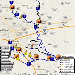
I saw a map on The Advocate’s story recently, and according to it, on Bayou Fountain, “Channel enlargement” is only planned for the Siegen/Burbank to Gardere section. Since that portion of Bayou Manchac is basically a wide-open mostly-dry reservoir with a channel at the bottom, the only thing widening it will do is temporarily disrupt the hydrilla farm it’s turned into. (Every time it rains, we get *bales* of hydrilla floating down the bayou, so anything that makes even a temporary dent in that invasive plant is a win at least in part.)
The rest of Bayou Fountain, along with Ward Creek (except the North Fork) and Dawson Creek, were listed as “Clear debris, blockages”. We can certainly attest to the presence of debris out there, as we’ve been keeping the channels flowing, but some of the fallen trees (and crane mats on Ward) are just too massive to completely remove by hand. On Bayou Fountain between the Screen Porch (about half a mile upstream from Manchac) to the big powerlines and Not-So-Great Wall of Fountain (about two miles from Manchac), they’ll certainly have to cut back the overhanging brushy trees and foliage to do any significant work on the channel, but there shouldn’t be a need to do anything drastic to the forested banks.
Having seen the map, I’m slightly less anxious than I was before seeing it, but we certainly would hope to provide at least some input or have some conversation before the big projects roll on. Thankfully, much of what was chopped by the surveying crew seems to have been recovering.