Project Clearwater — Expedition Twenty
Project Clearwater — Expedition Twenty
After last week’s amazing cleanup, Saturday was back on the bayou again. With so little litter remaining and not a single complete blockage, not even a small one, it seemed like a great day for a marathon scouting paddle.
The work to get the bayou ready for the cleanup had been considerable, but it was definitely worth it. Still, now that Bayou Fountain is open for paddling and vastly cleaner, it seemed like a good weekend to take a breath. Mike headed off to get in some much-postponed bike time riding the Longleaf Trace in Mississippi, and I decided to gear up for a lighter-than-usual day on the bayou. I didn’t even bring the heavy tackle, as I figured (or at least hoped) that there would be nothing too large to handle. Actually, I even forgot my paddles, but a quick run back to the house still left me ahead of schedule, and I was launching down the bayou right around 8am.
Towing the Canoemaran and trailer canoe back up the bayou last weekend, I didn’t have much opportunity to look around. Now, heading down the bayou with a pleasantly light load, I finally got to take a good look around. The difference was night and day. I have quite literally never seen Bayou Fountain looking as good as it does now, and we rather intend to keep it this way. We’re going to go collect the half dozen barrels one of these days (and it won’t be too long), and the bayou’s not *completely* clean (especially a couple spots where there were snakes during the cleanup), but it’s fantastic.
Speaking of snakes, there were a few out there, but mostly just these nice little guys. They’re mellow and couldn’t care much less about someone paddling by (usually on the *other* side of the bayou, hehe). Don’t try to catch them or hit them with a paddle and they won’t bug you at all. They’ll even usually ignore you if you happen to be one of those people who likes to ease a bit closer to get a good photo, unlike the turtles. To see turtles, you have to look far ahead, as they all plop into the water as soon as they see you. It makes for entertaining noises, but it tends to make getting good photos a bit harder. There were also multiple sets of ducklings out there, but I felt bad enough with the mother duck leading me away with her “wounded duck dance” that I didn’t want to disturb them by trying to get snapshots, even if they *are* sooooo cute.
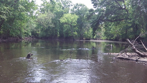
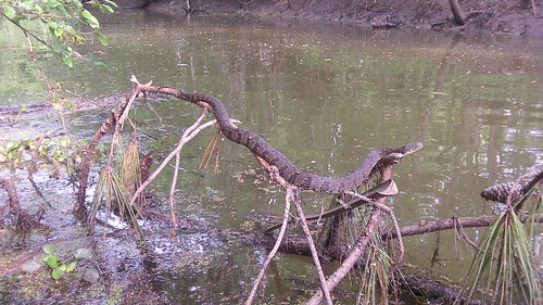
I expected to hit a small blockage or few on the way down. Nothing that can’t quite easily be paddled right across, usually, but there are still quite a few long logs that haven’t quite settled yet. I was just a bit surprised as the mile markers kept counting down toward Bayou Manchac with nary a problem encountered. Surely there would be something by the halfway point, but no. The area right around mile marker one is still active, but not even that had anything completely across. With no real problems, just a few small catches, it seemed like an excellent opportunity to press on as if this were a through paddle to a future Airline Highway Park/Manchac Park paddle launch.

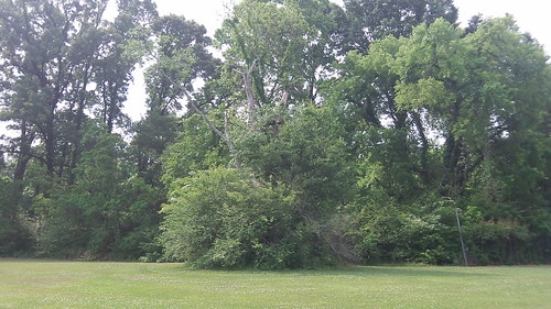
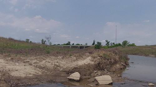
Bayou Fountain had negligible current, but Bayou Manchac was flowing with water coming down from the Alligator Bayou/Frog Bayou end. Making almost five miles an hour in a canoe reminded me of my Hobie pedal kayak. In short order, I had made it all the way to Ward Creek, two miles down from the end of Bayou Fountain. There’s no paddle launch there yet, so I continued another 3/4 of a mile to the “launch” at Manchac Park. If you look closely, you can tell you’ve arrived when you see the water fountain (pictured above) mysteriously standing guard just up the bank. If you get to the Jefferson Highway (73) bridge, you’ve missed it. If you’re launching from the park, look for the small “trail” just behind the left side of this little cluster of trees between the two baseball fields. It’s not far, but the entry/exit is a bit… interesting.
After a quick stop to stretch and take some photos, it was back to the canoe for the paddle upstream. It had only taken an hour and 40 minutes to paddle from Highland Road Park to Manchac Park. Even if you assume I’m in prime paddling shape and almost double my time, that’s still only about a three-hour tour. (Don’t bring Gilligan!) The going was a bit slower paddling upstream, but it wasn’t bad, and I found myself back at Ward Creek several minutes shy of 10:30am. It would just feel wrong to head back to the park and wrap up the day practically by lunchtime, so I took a right.
With all our time spent on Bayou Fountain, it’s been a while since we’ve been very far on Ward Creek. The first thing I noticed is that there is currently much more floating small litter along the banks than I recall from earlier trips. It’s ripe for a cleanup. I was pleased that the small tributary that had been exceedingly malodorous on my last time by was now completely nominal. (Nobody likes to hold their breath while they paddle.) Ward Creek is somewhat more open to the wind and has a bit less shade than Bayou Manchac, which is much more open and less shaded than Bayou Fountain. Manchac and Ward are both still great places to paddle, but Bayou Fountain is exceptional in hot weather.

About 2-3/4 miles up from Bayou Manchac is the derelict bridge near the end of Buzbee Drive. We spent more than a bit of time on that quite a while back, and I’m happy to report that it is still passable. When we get a launch on or near Ward Creek, we’ll likely attack it again to improve it some more, along with the bridges at Barringer and Pecue, but all three are open and present no obstruction to paddling at present. There were no exceptionally large litter accumulations at any of the bridges. The same could not be said about the litter banks near Siegen, which are ripe for the picking. We’ll add them to the list as well.
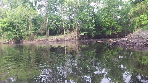
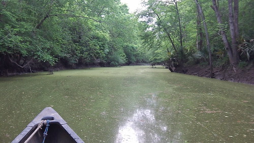
As you paddle up Ward Creek, right around Siegen Marketplace the partial shade gives way to a wide open, tree-less expanse. Passing under Siegen, you reach what we call “Lake Ward”, where the water is wide and flat and completely unsheltered. This is also the section of Ward Creek along which the initial phase of the Capitol Area Pathways Project trail has been built (except the bridge, which is coming soon… hopefully by fall or so). It’s not the best place to paddle, but if at some future time you could launch from a CAPP trailhead, it would be an easy and not too long paddle to get to the shaded, tree-lined portion of Ward Creek. At present, you can easily paddle just upstream of the High Grove apartments to within sight of the bridge at the I-10 Mall of Louisiana exit. (There you hit an equipment crossing, which you can see in more detail by clicking through the photo above and flipping left.)
It was a bit of a long paddle back down Ward Creek to Bayou Manchac, than upstream against the current to Bayou Fountain, but it certainly made Bayou Fountain seem all the more wonderful a paddle trail. I still had enough energy left to pull out and saw up the few stray branches long logs that were catching just a bit. With the trees providing plenty of shade and shelter from the winds, it was quite relaxing. I suppose it’s good that I’m not much affected by allergies, as the surface of the bayou appeared in areas to be completely covered in a coating of pollen.

It had been a while since I’ve done a long recon run, and canoeing 27 miles over a nine-hour trip was a blast. I can happily report that all three waterways, Bayou Fountain, Bayou Manchac, and Ward Creek are open to paddling without obstruction. The “primitive launches” at Highland Road Park and Manchac Park are usable, although we are hoping to make progress on making access easier. And of course, there is indeed a bit of cleanup needed. Stay tuned.


Have you ever paddled up Dawson’s Creek? It’s a tributary of Ward’s.
Dawson Creek at Ward Creek:

I have attempted to paddle up it. In that photo you can see to the first little dogleg bend, and just beyond that I ran out of water. There was a little cascade over rubble, and it didn’t look like it got much better.
I’d like to scout it out with a bit more water around to get a better sense of its potential, but running out of water so close to the confluence with Ward has it on the low-priority list for now.
I’ve been up Dawson’s as far as Bluebonnet but it was rough going. From your description, not much has changed.